|
|

|
|
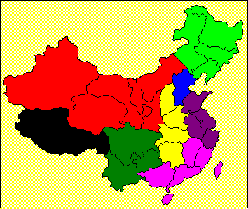
Tibet is shown
in black. Note that Chinese names are in MingLiU (Chinese Traditional) screen
font. This may appear as question
marks or other symbols if that font is not installed on your browser. |
||||||||||||||||||||||||||||||||||||||||||||||||||||||||||||||||||||||||||||||||||||||||||||||||||||||||||||||||||||
|
|
Regional Capital: Lhasa Average temperatures: -18 deg C to 4 deg C in January; 7 deg C to
19 deg C in July. Physical features: Most of the region is a high plateau, known as the roof
of the world. The vast Northern Tibet Plateau, which is part of the Qinghai-Tibet plateau(青藏高原) contains hills, basins, lakes and snow-capped peaks. The southern valleys are Tibet's principal
farming and pastoral lands. The region
has long hours of sunshine and intense solar radiation. The average elevation is nearly 5,000
metres above sea level and the total land area of the region is 1,228,400
square kilometres. Rivers:
The Brahmaputra River winds it way through Tibet's southern valleys before
flowing into Arunachal Pradesh and Assam states in India, then into
Bangladesh and the Sea of Bengal. The
Salween River (Nujiang) originates in the north-central part of the region
and subsequently flows into Yunnan Province and
Myanmar. The Mekong River (Lanchang) begins in Qinghai Province and flows
through the northeast corner of Tibet. Similarly, the upper part of the
Yangtze River arises to the north and forms Tibet's eastern border. Administrative divisions: 2 cities and 76 counties. Historical Significance: Lamaism, a form of Buddhism, has traditionally been
extremely important to the people of Tibet, and the all-pervasive monasteries
once controlled much of the religious, economic, political, and educational
life of Tibet. Tibet became part of
China in 1950. Tibet is the largest resident place in China for
the Tibetan(藏族)which accounts for 96% of the region's
population. Other groups are Han(漢), Hui(回), Mongolian(蒙古), Monba(門巴)and Lhoba(珞巴). |
||||||||||||||||||||||||||||||||||||||||||||||||||||||||||||||||||||||||||||||||||||||||||||||||||||||||||||||||||||
|
|
The region also has the largest forested
areas in China. |
||||||||||||||||||||||||||||||||||||||||||||||||||||||||||||||||||||||||||||||||||||||||||||||||||||||||||||||||||||
|
|
Notes: *Estimated |
||||||||||||||||||||||||||||||||||||||||||||||||||||||||||||||||||||||||||||||||||||||||||||||||||||||||||||||||||||
|
|
|
Roadways -- Transport in Tibet mainly relies on highways and Lhasa
is the pivot in the region. So far, Tibet has 22,000 kilometres of
roadways. The region connects Sichuan, Qinghai, Xinjiang and Yunnan through
Chuan-Tibet line(川藏線), Qing-Tibet line(青藏線), Xin-Tibet line(新藏線)and Dian-Tibet line(滇藏線)as well as the China-Nepal highway (中尼公路)which links up Lhasa to
Katmandu in Nepal. A new roadway that extends from Ping'an to Xining of Qinghai is under
construction. The highway is a portion
of Lanzhou-Xining expressway with average altitude over 2,000 meters. Air Transport -- The Gonggar Airport(貢嘎機場)and Bangda Airport(邦達機場)provide more than 25 domestic and international
air routes to Chengdu,
Chongqing, Beijing, Xi'an,
Qinghai, Katmandu
in Nepal, etc. A new air route to
Shanghai has been in operation since April 2000 and it takes approximately 4
hours from Lhasa to Shanghai with a stopover in Xi'an. Telecommunications -- In 2000, there were 4.7 telephones per 100
persons. In May 2001, the Lhasa – Ali
(拉萨 -阿里) optic cable was constructed. Every region of Tibet is now accessible by
phone. Mobile phones services are
available in various Tibet cities such as Lhasa, Xigaze, Ningchi, Qamdo,
Naqu and Ali(阿里). Electricity
Supply -- The
Yangbajing(羊八井) Station is the largest
geothermal power plant in the country and has an installed capacity of 25,000
kWh. Because of its altitude, the
region also has the potential for both solar and hydropower. Currently there are over 20 small and
medium size solar power plants in a number of counties. Other projects underway include the Yamzhog
Yumco Lake Hydro-Electric Power Station and the Chaglung (查龍) Power Station, which have
total installed capacity of 112,500 kWh and 10,800 kWh respectively. The
expansion of the Yangbajing Geothermal Power Station provides an additional
capacity of 50,000 kWh. |
|||||||||||||||||||||||||||||||||||||||||||||||||||||||||||||||||||||||||||||||||||||||||||||||||||||||||||||||||||
|
|
|
||||||||||||||||||||||||||||||||||||||||||||||||||||||||||||||||||||||||||||||||||||||||||||||||||||||||||||||||||||
|
|
Tibet has more than 500 industrial enterprises,
which mainly engaged in foodstuffs, energy, timber processing, mineral,
textiles and light industries. The
region has established its own brand including mineral water(西藏礦泉水), Lhasa Beers, Chinese and Tibetan medicinal
herbs, carpets and other similar items.
|
||||||||||||||||||||||||||||||||||||||||||||||||||||||||||||||||||||||||||||||||||||||||||||||||||||||||||||||||||||
|
|
The rediscovery of Tibetan traditional medicines
also led to several medical breakthroughs and stimulated further research and
development in the region. |
||||||||||||||||||||||||||||||||||||||||||||||||||||||||||||||||||||||||||||||||||||||||||||||||||||||||||||||||||||
|
|
Other major shopping centers include: Lhasa Renyi
Integrated Market (拉薩仁益綜合商場), Saikang Business Centre(塞康商业中心). |
||||||||||||||||||||||||||||||||||||||||||||||||||||||||||||||||||||||||||||||||||||||||||||||||||||||||||||||||||||
|
|
Southern industrial zone – along the
Brahmaputra River: Ø Lhasa Ø Xigaze Ø
Ningchi
and North-central industrial zone – along the
Salween or Mekong rivers. Ø Qamdo and Ø Nagqu |
||||||||||||||||||||||||||||||||||||||||||||||||||||||||||||||||||||||||||||||||||||||||||||||||||||||||||||||||||||
|
: |
Lhasa lies in a plateau and is about 200
kilometres from the border with Bhutan.
It has long been the capital of Tibet and remains the cultural
centre. Income per capita is surprisingly
high, due mainly to the high wage rates that are needed to attract migrants
into the region. Substantial fiscal transfers to the region
are made by the central government. |
||||||||||||||||||||||||||||||||||||||||||||||||||||||||||||||||||||||||||||||||||||||||||||||||||||||||||||||||||||
|
Xigaze is about 250 kilometres directly
west of Lhasa, along the Brahmaputra River which it
shares with Lhasa.
|
|||||||||||||||||||||||||||||||||||||||||||||||||||||||||||||||||||||||||||||||||||||||||||||||||||||||||||||||||||||
|
Qamdo is situated along the Mekong River
and is about 650 kilometres northeast of Lhasa. |
|||||||||||||||||||||||||||||||||||||||||||||||||||||||||||||||||||||||||||||||||||||||||||||||||||||||||||||||||||||
|
Nagqu is only 250 kilometres northwest of
Lhasa, but is classified as being part of the north-central region since it
lies along the Salween River. |
|||||||||||||||||||||||||||||||||||||||||||||||||||||||||||||||||||||||||||||||||||||||||||||||||||||||||||||||||||||
|
No additional information is available
about Shannan. |
|||||||||||||||||||||||||||||||||||||||||||||||||||||||||||||||||||||||||||||||||||||||||||||||||||||||||||||||||||||
|
Ningchi is about 350 kilometres directly
east of Lhasa, near the portion of the Brahmaputra River that bends southward
toward India. |
|||||||||||||||||||||||||||||||||||||||||||||||||||||||||||||||||||||||||||||||||||||||||||||||||||||||||||||||||||||
|
|
Hong Kong Trade Development
Council (http://www.tdctrade.com) |
||||||||||||||||||||||||||||||||||||||||||||||||||||||||||||||||||||||||||||||||||||||||||||||||||||||||||||||||||||
|
|
|
||||||||||||||||||||||||||||||||||||||||||||||||||||||||||||||||||||||||||||||||||||||||||||||||||||||||||||||||||||