|
|
|
|
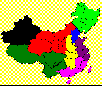
Xinjiang is
shown in black. Note that Chinese names are in MingLiU (Chinese Traditional) screen
font. This may appear as question
marks or other symbols if that font is not installed on your browser. |
||||||||||||||||||||||||||||||||||||||||||||||||||||||||||||||||||||||||||||||||||||||||||||||||||||||||||||||||||||
|
|
Regional Capital: Urumqi Average temperatures: North: -20 deg C to -15 deg C in January
and 22 deg C to 26 deg C in July. South: -10 deg C to -5 deg C in January and
the same temperature range as in the north in July. Physical features: The autonomous region consists of 1,650,000 square
kilometres, which is 16 per cent of China’s total land area. Three major
mountain ranges separate the lowlands into various basins and valleys with a
substantial difference in elevation.
The region has very little precipitation and experiences frequent
gales in the spring and autumn. Rivers:
The Tarim River and its tributaries (Hotan and Yarkant) comprise China's
longest inland river. Ulanqur River is in the north of the region. Administrative divisions: 16 cities, 5 autonomous prefectures, 65 counties and 6
autonomous counties. Historical significance: Xinjiang Uyghur Autonomous Region has a long history
of conflict, stemming from the silk trade (which dates back to the Roman
era), and a collection of nomadic tribes that occasionally intruded into
China. It was part of China during the
Qing Dynasty but was ruled by warlords when the Qing Dynasty collapsed. Apart from a portion that became
independent as the Republic of Turkestan in 1945 (now separated into
Kazakhstan, Kyrgyzstan and Tajikistan) the region remained with China. Major ethnic
groups in the region are Uyghur(維吾爾)and Han(漢), accounting for 47 per cent and 39 per cent, respectively, of the
region's population. Other ethnic
groups include Kazak(哈薩克), Hui(回), Kirgiz(柯爾克孜), Mongolian(蒙古), Tatar(塔塔爾), Daur(達幹爾), Xibe(錫伯), Russian(俄羅斯), Tajik(塔吉克)and Uzbek(烏孜別克). |
||||||||||||||||||||||||||||||||||||||||||||||||||||||||||||||||||||||||||||||||||||||||||||||||||||||||||||||||||||
|
|
It has the
largest reserves of oil, natural gas and coal in the country. Its coal reserves amount to 27 million tons
(40 per cent of the country’s total) and oil reserves amount to 30 billion
tons. Crude oil output, which reached
17.4 million tons in 1999, was the third highest in the country. The oil and gas reserves found in Tarim,
Junggar and Turpan-Hami basins in the region account for one-fourth and
one-third, respectively, of the country's total. Xinjiang's
reserves of mineral resources are also substantial. The region's reserves of beryllium(鈹) and mica(雲母) are the highest in
China. Some of the region’s granite
products such as “Xinjiang Red,” Tianshan White” and “Snowflower Black” are
famous brands in the country. The
country’s largest copper mine is also found in Xinjiang. |
||||||||||||||||||||||||||||||||||||||||||||||||||||||||||||||||||||||||||||||||||||||||||||||||||||||||||||||||||||
|
|
Notes: *In real terms |
||||||||||||||||||||||||||||||||||||||||||||||||||||||||||||||||||||||||||||||||||||||||||||||||||||||||||||||||||||
|
|
|
Roadways - The total length of roads and
highways in the region reached 35,600 kilometres by the end of 2000, covering
over 99 per cent of the counties, townships and villages. Major highways include Tur-U-Dai(吐烏大: Turpan-Urumqi-Daihuangshan
吐魯番-烏魯木齊-大黃山), U-Kui Expressway(烏奎 : Urumqi-Kuitun 烏魯木齊-奎屯), LanXin line(蘭新線: Lanzhou-Xinjiang 蘭州-新疆), QinXin line(青新線: Qinghai-Xinjiang 青海-新疆)and Xin-Tibet line(新藏線: Xinjiang-Tibet 新疆-西藏). Air
Transport - The Urumqi Airport has
flight services to 59 international and domestic destinations including
Ningbo, Shenyang, Xi'an,
Moscow, Siberian and Islamabad. The
reconstructions of the Yili Airport in 1998 and the Karsh
Airport in 1999 have improved the aviation services of Xinjiang. Telecommunications - Program-controlled telephone exchanges are
available in 98 per cent of township and 52 per cent of administrative
villages in Xinjiang. At present,
there are about 1.7 million telephone users in the region. Direct dial service for international calls
is also available. Mobile phone
service is increasingly popular. By
the end of 1999, there were 180,000 mobile phone users in Urumqi. Xinjiang built a
digital microwave telecommunications trunk which links cities on both sides
of the Tianshan Mountain, and an optical fibre cable system leading to
neighbouring countries with a total length of 25,000 kilometres, and 10
satellite ground stations. The region
has also set up a digital data network, a conference TV system, a smart
terminal and a multi-media network.
The number of data transmission users has risen to more than 105,000. Wind
Power - More than 200 power-generating units are in
operation at the wind power centre in Dabancheng(大板城). The generating capacity of the canter makes
up one-third of the total installed wind power capacity in the country. Gas
Supply - Under China's energy development strategy, a
major gas pipeline running from the Tarim Basin to Shanghai with a total
length of 4,167 kilometres will start construction in the last quarter of
2001. The pipeline, which runs through
Gansu, Shaanxi, Shanxi, Henan, Anhui and Jiangsu
and Ningxia Hui
Autonomous Region, will be able to transmit 12 billion cubic metres of
gas annually from the west to the east upon completion by end of 2003. |
|||||||||||||||||||||||||||||||||||||||||||||||||||||||||||||||||||||||||||||||||||||||||||||||||||||||||||||||||||
|
|
It provides more than 40 per cent of the
country's total fine-sheep wool and its milk production in the region ranked
the fourth in China in 1999. Xinjiang
is also a major producer of grain, sugar beets and fruits, of which, Yining apples, Korla pears, seedless white grapes and Hami
melons are famous at home and abroad. |
||||||||||||||||||||||||||||||||||||||||||||||||||||||||||||||||||||||||||||||||||||||||||||||||||||||||||||||||||||
|
|
Heavy industries
like oil, petrochemicals and coal production formed a fundamental part of
Xinjiang’s industrial development, accounting for 69 per cent of the region’s
total industrial output in 1999.
Besides, the region has developed light industries like textiles and
garments (especially wool and cashmere), leather processing, papermaking,
sugar refining and carpet weaving. The
Xinjiang’s government targets to accelerate development of information,
biotech, energy and environmental protection industries in the current
Five-Year Plan period. Major export
items included canned food, cotton, garment, silk products and woolen yarn. |
||||||||||||||||||||||||||||||||||||||||||||||||||||||||||||||||||||||||||||||||||||||||||||||||||||||||||||||||||||
|
|
This zone engages in the chemical industry,
textiles, foodstuffs, construction materials, medicines and other light
industries. An International
Trade/Tourist Shopping Market (國際貿易旅遊購物市場)was open in the zone during 1998 to attract more
foreign investment. Urumqi High-tech Development Zone(烏魯木齊高新技術產業開發區) This zone focuses on high-tech and service
industries. It achieved an output of
RMB 702 million and total trade US$71.8 million during 1999. Shihezi
Economic and Technological Development Zone (石河子經濟技術開發區) This zone is
devoted mainly to light industries. In
1999, there were 244 enterprises located in the zone, with an industrial
output of RMB 571 million and foreign trade of US$13.6 million. Yining
Border Economic Cooperation Zone(伊寧邊境經濟合作區), This was
approved by the State Council in June 1992 as an important base for
agricultural products. Bole
City Border Economic Cooperation Zone(博樂市邊境經濟合作區), This state-level
zone approved by the State Council in December 1992, mainly engages in export
processing industry, machinery, science and technology, medicine processing
and mining industry. Kuytun Economic and Technological
Development Zone(奎屯經濟技術開發區), This is located to the west of Urumqi
and is the third largest industrial production centre in Xinjiang. |
||||||||||||||||||||||||||||||||||||||||||||||||||||||||||||||||||||||||||||||||||||||||||||||||||||||||||||||||||||
|
|
Major department
stores and shopping centres in Xinjiang include Urumqi Tianshan Department
Store(烏魯木齊市天山百貨大樓), Urumqi Youhao Department
Store(烏魯木齊市友好商場股份有限公司), Xinjiang Department Store(新疆百貨大樓), Hongshan Shopping Arcade(紅山商場), Urumqi Dashizi Commercial
Building (烏市大十字商業大廈), Tulufan Department Store(吐魯番百貨站), Hami Department Store(哈密百貨站)and Xinjian Shengchan
Jianshe Bingtuan Department Store(新疆生產建設兵團百貨公司). |
||||||||||||||||||||||||||||||||||||||||||||||||||||||||||||||||||||||||||||||||||||||||||||||||||||||||||||||||||||
|
|
Ø Urumqi Ø Yili Ø
Changji Ø
Ba Ø Karamay Western industrial zone – this includes the western portion of the Tarim
Basin. Ø
Kashi |
||||||||||||||||||||||||||||||||||||||||||||||||||||||||||||||||||||||||||||||||||||||||||||||||||||||||||||||||||||
|
As with many of the far western
communities, Urumqi amounted to very little before the construction of the
rail line from Lanzhou
in the 1950s. The city is noted for
the relatively high percentage of people with Turkic ancestry. |
|||||||||||||||||||||||||||||||||||||||||||||||||||||||||||||||||||||||||||||||||||||||||||||||||||||||||||||||||||||
|
The full name is Yili Kazak Autonomous
Prefecture, which gives it an administrative level that is between a province
and a municipality. Autonomous
prefectures are associated mainly with minority national areas. The data reported above include Yining,
which is the capital city of the Yili Autonomous Prefecture, as well as much
of the surrounding region along the Ili River. This river flows westward from the
mountains lying to the southwest of Urumqi into Kazakhstan. Agriculture is the principal activity in
the autonomous prefecture. |
|||||||||||||||||||||||||||||||||||||||||||||||||||||||||||||||||||||||||||||||||||||||||||||||||||||||||||||||||||||
|
Changji is relatively close to Urumqi (about 35 km, which is very close in relation to
the distances within Xinjiang). It is
connected to the capital by road, but not by rail. |
|||||||||||||||||||||||||||||||||||||||||||||||||||||||||||||||||||||||||||||||||||||||||||||||||||||||||||||||||||||
|
Ba is the short form of a Mongolian
autonomous prefecture in Xinjiang.
(See the discussion above with Yili for the nature of autonomous
prefectures.) The full name appears to
be Ba Yin Guo Leng Mongolian Autonomous Prefecture. It probably consists of the northern tip of
Xinjiang and may include the cities of Altay and Qingha, but not enough
information is available to be certain.
|
|||||||||||||||||||||||||||||||||||||||||||||||||||||||||||||||||||||||||||||||||||||||||||||||||||||||||||||||||||||
|
Karamay
is on the northern edge of the Junggar Plain that lies north of Urumqi. It is a
little less than 300 kilometres from Urumqi and is
dominated by mining activities and related industries. |
|||||||||||||||||||||||||||||||||||||||||||||||||||||||||||||||||||||||||||||||||||||||||||||||||||||||||||||||||||||
|
Kashi, also known as Kashgar, is located in
the far western part of the Xinjiang, not far (about 100 km) from the border
with Kyrgyzstan. The Tian Mountains
lie to the north, the more rugged Kunlun Mountains to the south and
west. The many rivers in the area
disappear into the Taklan Makan Desert to the east. The city is dominated by rural activities
within the resulting basin. |
|||||||||||||||||||||||||||||||||||||||||||||||||||||||||||||||||||||||||||||||||||||||||||||||||||||||||||||||||||||
|
|
Hong Kong Trade Development
Council (http://www.tdctrade.com) |
||||||||||||||||||||||||||||||||||||||||||||||||||||||||||||||||||||||||||||||||||||||||||||||||||||||||||||||||||||
|
|
Urumqi Sub-Council of the China
Council for the Promotion of International Trade (CCPIT), which is also called the China Chamber of International
Commerce. We are in the process of maintaining
regular contact with organisations in the cities listed. Please contact us if you require additional
information about Xinjiang Uyghur Autonomous Region or any of the cities
listed. |
||||||||||||||||||||||||||||||||||||||||||||||||||||||||||||||||||||||||||||||||||||||||||||||||||||||||||||||||||||