|
|
|
|
|
|
|
|
8 March
2002 CONTENTS: Contrasts
with European Development Treaty
Ports – A Case Study of Shanghai Difficulties
With Central Planning Current
Strategy for Urban Development Megacities
– A Case Study of Chongqing Wider
Implications of Urban Development Related Documents Position Paper on Sister State and
Sister City Relations Between Australia and China
|
|
|
|
|
|
Specifically, the main points
are as follows: v
The development of cities in China differed
substantially from that of European cities.
An understanding of this difference is necessary in order to avoid
incorrect inferences based upon Western experiences. v
China’s recent urban development strategy differs
from previous strategies. Once again,
an understanding of both past and present circumstances is needed in order to
evaluate this strategy. The position paper proceeds
chronologically, beginning with the Xia Dynasty. Three case studies are used to illustrate urban development in
successive time periods of the modern era: Shanghai, Wuhan and Chongqing. For the purpose of this
overview, it is desirable to skip ahead in order to let the reader know what
is in store. In 1997, Chongqing was
restructured as a municipality that is equal to a province. The new governmental authority contains a
population of 30 million people and encloses a region with a distance
approximately equivalent to that from Sydney to Griffith in an east-west direction,
and from Batemans Bay to Taree in a north-south direction. This was achieved by
amalgamating cities, towns and rural areas into a municipal arrangement, but
it was not a process of centralisation since those same cities, towns and
rural areas were similarly centralised under the jurisdiction of Sichuan
Province. The separation of these
units from the province, and effectively given to Chongqing Municipality, is
more a division or decentralisation in creating two equally ranked
administrative units rather than only one. The division was made with the
view to assisting the development of the new region. It is our opinion that the strategy is
likely to succeed and may serve as a model for similar regional
restructurings. We also believe that
this urbanisation format will be effective in creating better linkages
between urban areas and rural areas in China. It may also contribute to a more
systematic development of small and medium sized enterprises (SMEs) in
China. However, this can be treated
as a separate issue and is one that will be discussed in a later position
paper.
|
|
|
|
|
|
Traditional settlements
throughout China consisted of dwellings that were built along or near fresh
water supplies, typically a river or stream, from which the agricultural
workers, as well as the hunters and gathers, journeyed outward to perform
their tasks. In China, at that time,
these were concentrated along the middle portion of the Yellow River. The Shang kings were known to
establish capital cities (court cities) that displayed early grandeur. The king appointed regional rulers who
formed an aristocratic class of military elite and established secondary cities. There is some evidence of conquest and
colonisation in outlying areas, particularly near the end of the Shang
period, and these military forces were most probably under the direct control
of the king. A fundamental change occurred
during the subsequent period, which is known as the Zhou Dynasty (1027 to 221 BC). The first Zhou king is reported to have
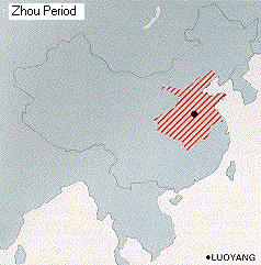
been a tribal chieftain who overthrew the last of the Shangs. The Zhou rulers extended the Shang territory to include much of the land between China’s two great rivers (the Yellow and the Yangtze). It represents approximately one-eight of present-day China, or slightly more than 1 million square kilometres, which is roughly equal to the combined area of France, Germany and Great Britain.
Partly as a result of the
relatively large territory, and perhaps also to offset the despotic
reputation of the Shangs, the Zhou kings established an administrative
structure which differed from the European version (discussed in more detail
below). It consisted of an amalgamation
of city-states that became progressively centralised, though not always as a
continuous process, and were dominated by increasingly impersonal political
and economic institutions. Although the system had feudal
elements, it is more accurately viewed as an extension of the earlier tribal
organisation, within which familial ties were more important than legal bonds
between the “peer of the realm” and his subjects. The system gave explicit recognition to local authorities and
attempted to provide a structure within which these authorities could serve
community interests, as well as demonstrating loyalty to higher-level
authorities. Land was typically distributed
by the king’s representatives (or vassals) by forming a series of rectangular
grids, each of which contained 9 squares in 3 rows and 3 columns. The outer 8 squares of land were each
allocated to a peasant family, who combined with other families working the
grid to cultivate the central square as a tax or tribute to the ruling
class. Thus, work groups rather than
individuals were taxed. Each local
ruler passed along a portion of this revenue to a regional ruler and a
portion of this was, in turn, passed to the king. This type of centralised control
was incomplete, however. Regional
warlords retained considerable authority and rivalry among them led to
disunity and civil unrest toward the end of the Zhou period (the Warring
States period). Regional cities nevertheless
prospered during this and the subsequent period, which is referred to as the Qin Dynasty (221
to 207 BC), with China’s first emperor.
This was due largely to massive public works projects, including walls
surrounding the cities, as well as continuing work on the Great Wall of
China. Urban development also benefited
from a significant change in the economic system during the Xin period (9 to 24 AD). Slavery was abolished; land was
nationalised and redistributed to the cultivators; imperial monopolies were
formed to control the distribution of salt, iron and coinage; and prices of
many other items were fixed by the state.
These conditions were well suited to the expansion of a commercial
class who could operate outside of the direct control of the aristocracy in
the trade of the non-regulated items.
The large landowners who were dispossessed
by the Xin emperor rebelled against the system during the latter part of his
reign. Many of his reforms were
repealed, but the basis for commercial activities in urban areas continued
and expanded substantially during the Song period
(960 to 1279 AD). In the interim period, between
the Han period (206 BC to 220 AD) and
the Tang period (618 to 907 AD),
China experienced considerable instability with a decline in central
administration. Towns and villages
undoubtedly grew larger, but did so without pattern or plan. This changed when the Tang
Dynasty strengthened the system of government that was supported by a large
group of Confucian scholars who were selected through competitive public
service examinations. The changes to
the system were intended to offset imperial dependence upon aristocratic
families and warlords, which had produced destabilising influences from the
latter part of the Zhou period. These public servants are often
referred to as mandarins. They were
part scholar, part magistrate and part public servant. They wore official robes with a cap of a
particular colour, depending on their rank.
They were not allowed to marry or to own property within their
assigned region, which they normally served for no more than three
years. They spoke a particular
dialect, which in English is called Mandarin. The ability of the mandarins to
achieve unity through imperial influence is more or less demonstrated by the
unchanged nature of the public service system from the Tang period until the
modern era. In relation to urban
development, they enabled villages to be amalgamated into towns and towns
into cities in a systematic way, depending upon the needs of the respective
communities. These amalgamations included
rural land that was originally part of the villages, resulting in cities in
modern China having both a rural population and an urban population. It is likely that a ranking of China’s
urban areas was approximately in line with the nine rankings of mandarins, so
that a successful amalgamation might have aided the advancement of those who
were instrumental in achieving it. The contribution of the
mandarins to social order in China is undoubtedly one of the reasons for the
durability of the system. These
public servants were key figures in their respective communities. They became part of the familial ties that
were an integral part of Chinese culture since the Zhou Dynasty. The mandarins resolved local disputes and,
through their devotion to higher order precepts, they provided a model for
the conduct of human activities. However, there was a cost
associated with the maintenance of social order through this system. Mandarins were, by nature,
tradition-oriented. They revered past
achievements and sought to replicate them rather than improve them. Their organisation was similar
to that of a monastic order, but without the religious trappings. Mandarins were dedicated to their Emperor,
but in a larger sense the dedication was to the entire line of emperors and
to their own ancestors. There was no
need to convert the local people to a different creed or philosophy; the
mandarins had only to remind them that they were part of a continuum of
people who occupied the same land for many centuries. This helps to explain the traditional
view the “middle kingdom” as the centre of the universe, with the universe
defined by the evolution of the Chinese people, including all of their
traditions and familial ties. It also
helps to explain why the various spoken languages and dialects had the same
written language. Written
communications were the principal responsibility of the mandarins, and their
enforced mobility prevented those communications from degenerating into
regional or local variations. As a result, the past was
perpetuated and there was little or no incentive for innovation. This greatly hindered productivity
increases that normally flow from technological improvements. Population pressures during the last of
China’s dynasties – the Qing (1644 to
1911 AD) – resulted in declining productivity per person and put China’s
fragile physical environment under considerable strain.
|
|
|
|
|
|
Memphis was the ancient capital of Egypt, within the Nile delta south of
Cairo. It is believed to have been
founded in the early part of the 4th millennium BC and was important during
the Old Kingdom period (3100 to 2242 BC). Babylon was located east of the Euphrates River, about 90 kilometres south of
present-day Baghdad. It was a
city-state by 1894 BC. Athens was fortified in 1400 BC and became a city-state in the mid 9th
century BC. Sparta consisted of a city containing only rulers and soldiers who descended
from the Dorian invaders about 1100 BC.
It was walled as a city-state at the end of the 4th century BC. Carthage in Tunisia was founded in the 9th century BC by Phoenicians. Byzantium was established at what is now Istanbul by Greek colonists in 660 BC. These dates span both the Xia
and the Zhou period in China (see the previous section). By the end of the period, however, the
European city-states differed substantially in terms of economic, social and
political structures. The Mediterranean Sea obviously
gave rise to water transport and facilitated trade and other commercial
interests within the region. In
China, in contrast, apart from salt and a few other items that were not
available in most provinces, each region sought economic
self-sufficiency. In ancient times,
only the court cities showed significant commercial interests and these were
of course completely dominated by the imperial courts. The social structure was
top-down and hierarchical in both the East and the West during the early
period, but, until the expansion of the Roman Empire, Western civilisations
were effective in incorporating only the city-state and its immediate
hinterland. Remote villages were not
subdued and therefore remained unconnected to the established
civilisation. Although the political system
varied in the city-states from elements of democracy in Ancient Greece and
Rome to a fully militaristic state in Sparta, citizenship was rigidly
controlled. The majority of
inhabitants in the cities were either slaves or women, neither of whom had
political rights. The system in China
did not provide for votes or plebiscites, but a non-binding consensus was
nevertheless formed within the village and town structure. Perhaps of greater importance
were the significant differences in migration. The almost continuous capture and transport of slaves around
the Mediterranean created a forced migration that did not occur in China. As noted previously, the movement of people
in China was restricted mainly to mandarins and soldiers. This acted as a substitute for the
movement of large numbers of people and preserved local characteristics under
a centralised “umbrella”. In ancient Europe, the
“umbrella” changed with the conquest of a city-state. The established institutions in the
conquered region were destroyed and there was little or no incentive, until
the end of the feudal period, for the victors to make them impersonal.
|
|
|
|
|
|
This changed with the fall of the Roman Empire, and
Medieval cities in Europe were, for the most part, designed to protect the
inhabitants and to impede invaders from reaching the centre of the city where
the more valuable structures were located.
This established a rectangular grid pattern of urban development, with
a concentric hierarchy. The Medieval urban plan was not well suited to the rise in
commerce following the breakdown of feudalism. As a result, commercial centres in European cities and towns
were generally established in the middle or outer portions of this concentric
pattern, with wider streets and a greater capacity to differentiate each
commercial establishment. The industrial revolution created even greater strain on
urban development and the increased amount of community awareness generally
resulted in some form of zoning for land usage. This met with varying degrees of success, depending upon the
level of authoritarianism exhibited by the municipal leaders in reconciling
the conflicting land-use claims. In China, there was little or no such conflict. Amalgamations of villages and towns were
determined by community needs when the natural rate of population growth
justified them. All such
amalgamations were principally administrative; they did not require a new
urban plan. The formerly separate
towns eventually grew together to form a continuous “built-up” area. This produced a greater uniformity, as compared to
European cities, but nevertheless created additional problems with
industrialisation. For a study of
those problems, a brief commentary on the institutional developments during
the 19th and 20th centuries is needed.
|
|
|
|
|
|
Guangzhou was
the first port that was opened to foreign trade, and efforts to expand direct
trade to North China led to increased conflict. These trade wars were resolved in favour of the European powers
and Japan, leaving China with a string of treaties that were perceived to be
unequal from the Chinese point of view.
Tianjin
and Shanghai were
added as “treaty ports”, in which foreign governments were able to lease land
and allow commercial enterprises from those countries to engage in trading
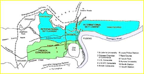
activities. Shanghai makes a useful
case study. The city was a frontier town during the 13th century. A wall was built around it in the 16th
century for the purpose of repelling Japanese pirates. The population size at that time is not
known, but it was classified as a county-level town, more specifically a
county seat, rather than as a city. The early settlement was near the area that become known
as “The Bund”, which is two kilometres south of a sharp bend in the Huangpu
River and on the western side of the river.
Pudong lies on the eastern side. The population of Shanghai in
1840 was about 50,000, and it was classified as a city at that time. It began to be an open port in 1845 and
this forever changed the nature of its development. The British were the first to
open a settlement on the leased land, which continued to be under Chinese
sovereignty but was nevertheless under the administrative control of the
British. France and the USA soon
followed, thus creating a leased area that was many times larger than the old
city.
Before 1853, residency in the international settlements
was restricted to Westerners, but in that year insurgency within the Old City
resulted in a flood of Chinese into the settlements. The legality of this migration was
uncertain, under the leasing arrangements (referred to as the “Land
Regulation”), but was nevertheless accepted by both the Chinese and the
foreign governments. The sharp rise in population
within the International Settlement and the French Concession created health
and sanitation problems. The Shanghai
Municipal Government was slow to respond, which is not surprising during the
period of rapid change and with a significant decline in central
authority. As a result, the foreign
governments unilaterally established a municipal council. A Foreign Ratepayers’ Meeting
was convened to include all who held leases, or sub-leases, in the
settlements. It resembled an annual
shareholders meeting, at which the forthcoming budget was approved, taxation
matters were agreed upon and the board of the Municipal Council was voted
upon. The Council administered all
municipal services, including water and sanitation. This represented the first clearly defined countermovement to centralisation in China since the Tang Dynasty. It also reflected the first instance in which economic and commercial development dominated urban planning. It was nevertheless hugely successful in relation to
urban growth. The area included in
the settlements at the beginning of the 20th century expanded to nearly
49,000 mu (about 32.5 square kilometres), which was 57 times larger than the
original settlements, and the population reached 1 million. However, the decentralisation of
administration led to fragmentation, with an International Settlement (mainly
British and American), the French Concession and the Chinese Section. Water, electricity, transport and communications
were supplied separately in each fragment, and with different standards. Inter-connectivity was poor or
non-existent. Efforts were made to alleviate
the inefficiencies of these arrangements, but an overall municipal plan did
not emerge until the 1930s, under the Kuomintang Government of the Republic
of China. Implementation of the plan
remained incomplete when the Japanese occupied the city in 1937. In the interim period,
Shanghai’s industrialisation increased at an exceptionally rapid pace, but
also carried all of the undesirable features of undisciplined development. With the formation of the
People’s Republic of China (PRC) in 1949, the Chinese Communist Party (CCP)
sought to eradicate the slums, rehabilitate the thousands of opium addicts
and bring an end to the exploitation of labour, especially child labour. This can be interpreted as a return to
centralisation, but it occurred in a different way, compared to Imperial
China.
|
|
|
|
|
|
First, a socialist system was
quickly established, through which all Chinese were guaranteed lifetime
employment with housing, education, health care, retirement and other social
benefits supplied by the state. This is often referred to as the “iron rice
bowl” concept. It was achieved by
nationalising all land and all manufacturing enterprises. State-owned enterprises (SOEs)
contained the basic work units in urban areas, and agricultural communes
provided the work units in rural areas.
The services and benefits mentioned above were supplied by the danwei, which were work groups within the SOEs or
within the communes. Initially rural-to-urban
migration was allowed, but the cities quickly became inundated with migrants
and the municipal authorities generally lacked the infrastructure to
accommodate them in a satisfactory manner.
Supplying this additional infrastructure would cut across the central
planning objective of substantial government investment in industrial
enterprises. This gave rise to the hukou, or family registration system that was
established in 1952. All residents
were issued identity papers that designated their respective work
groups. Typically a newly married
woman would join the danwei to which her
husband belonged, and since these enterprises supplied health and educational
facilities for the children, the children also belonged to a specific danwei. The transfer from one work group to another, and therefore from rural areas to urban
areas, was allowed only in special circumstances. Migration was generally permitted for purposes of education or
to obtain employment as a result of a special skill. Approval was generally needed by the
administrative officer of the both the previous and the new work group. This “double” approval rarely occurred. The obvious impact of the hukou system was to create inefficiency by limiting
mobility of workers. It also slowed
the rate of urbanisation. Second, the Government of the
PRC dominated economic decision-making.
The State Planning Commission set output targets on an annual basis
for each industry, and allocated a specified portion of the output to the respective
provinces. Inputs needed to achieve
these outputs were calculated and the deliveries of the inputs to the SOEs
were scheduled. Prices were set on
the basis of the input requirements. Third, an administrative process
for three levels of government was established. This included the central government, provincial governments
and municipal/county governments. The central government
is of course located in Beijing with various ministries and departments. The second level consists, currently, of 31 provincial-level
administrative units: 22 provinces, 5 autonomous regions, and 4 special
municipalities that are equal to provinces.
Each of these units has a provincial-level people’s congress, which is
the legislative body, and each such body has a selection committee that
appoints the principal administrative officers. These administrative officers are governors and vice governors
for the provinces and autonomous regions, and mayors and vice mayors for the
4 special municipalities. The
appointments are made from a list of approved candidates supplied by the
central government. The third level consists of autonomous prefectures,
counties, autonomous counties, cities, and municipal districts. This is sometimes described as the
county-level administration even though it includes a number of large
cities. These mayors have some autonomy in decision-making within
their respective jurisdictions, but report to the provincial authorities
rather than to the central government.
The selection committees of municipal/county people’s congresses make
appointments to these administrative positions from a list of approved
candidates supplied by the provincial-level government. Fourth, the Government of the PRC looked upon
international trade as a failure of central planning. It was not embraced for the purpose of
achieving gains through international specialisation and division of
labour. National self-sufficiency was
an extension of the regional self-sufficiency that existed in China for
centuries, and the policy also served to remove the influence of
foreign-owned enterprises.
|
|
|
|
|
|
Additionally, Hubei Province is
rich in mineral resources with 111 minerals found there, accounting for 74
per cent of all the 150 minerals already found in China. Perhaps of greater importance, the
deposits include many metals such as iron and copper, as well as minerals
that contribute to metallurgical processing. Wuhan lies along the Yangtze
river, which formed a major inland transport system since ancient times, at
the point where the Han River joins the larger one. It is therefore not surprising that the central government
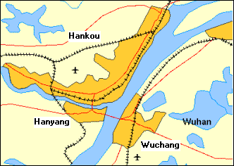
selected it as a site for iron and steel making. In 1950 the cities of Wuchang,
Hankou, and Hanyang were combined into one administrative unit, and given the
abbreviated name Wuhan. The former
cities are now districts within Wuhan. Hankou, the commercial centre and largest of the three, occupies the
northern quadrant, lying mainly on the western bank of the Yangtze with a
smaller land area along the Han River.
Hanyang is a manufacturing and
residential section lying south of the Han River and the western bank of the
Yangtze. Finally Wuchang, the administrative and educational
centre, as well as the location of the provincial capital buildings, is
situated on the eastern bank of the Yangtze.
This type of amalgamation
enabled a large manufacturing complex to be established through a combination
of urban development and urban renewal.
In this case, the three (former) cities were separated by water, so
there was no tendency to grow together, but expansion could nevertheless
proceed in a planned and coordinated manner. The area was first settled more
than 3,000 years ago during the Han Dynasty.
Hanyang became a fairly busy port, and in the first and third
centuries AD walls were built to protect both Hanyang and Wuchang. Hankou became one of China’s four busiest
trading towns about 300 years ago and became a “treaty port” in 1841. The city was part of an uprising
during the 1911 revolution and most if it was burned, except for many of the
foreign-concession buildings. These
have distinct European features.
Digital photographs are available at: http://www.geocities.com/wuhanese/wuhan/wuhan.htm. Note especially the photograph of the old
customs house. This contrasts with
traditional Chinese architecture as shown in the photograph of the Yellow
Crane Tower. In the early part of this
century, Wuhan became the centre of revolutionary activity. The movement led by Sun Yat-Sen, that
resulted in the overthrow of the Qing Dynasty on 1911, began there. The town's workers were in the forefront
of the national strike in 1933, and the Central Peasant Movement Institute,
where Mao Zedong taught Communist theory, was established there in 1936. Thus, the basic ingredients for
centrally controlled development of the new city were in place – central
location, available natural resources and historical significance for the
Chinese Communist Party. The
municipal government administration was effectively reconstituted when the
original cities were amalgamated. New
administrators were recruited and given the power to organise the bureaucracy
in such a way as to achieve the planning objectives. The
mixture of urban development and urban renewal resulted in wider
thoroughfares, as compared to many other cities in China. Despite an urban population of about 4
million (with an additional 3,300,000 living in rural areas that are under
the jurisdiction of the municipal government) and an urban population density
of more than 2,500 people per square kilometre, the city functions
surprisingly well. Urban
development in Wuhan was nevertheless uneven. This was due partly to the inherent difficulties with the
central planning system (discussed in the next section). Additionally, when economic reform began
in 1979, Wuhan was slower to adapt to a more market-oriented system, compared
to the coastal cities. This can be
explained partly by the more entrenched bureaucratic apparatus that was
established with Mao Zedong’s blessing in 1950. Recent
changes have nevertheless occurred in Wuhan, particularly with the current
plan to develop the western provinces in China. As a result, Wuhan is rapidly catching up with the coastal
cities. The data in Annex A indicate
that recent growth rates and figures for GDP per capita put the city among
the top 10 in China.
|
|
|
|
|
|
Second, production targets were
met with inefficient use of resources (natural resources as well as human
resources). Modern technology was
needed to lift output per worker, and an opening of trade with the rest of
the world was considered to be the best way to achieve this. Additionally, the “iron rice
bowl” concept, discussed previously, resulted in severe financial burdens for
both state-owned enterprises and communes.
This extensive social welfare system, organised through work groups,
experienced costs that escaladed much more rapidly than industrial
productivity. China’s central government
therefore embarked on a program of opening to the outside world through
international trade and allowing foreign enterprises in China. This was accompanied by a return to family
responsibility in farm management (the ending of the commune system) and decentralisation
in the management and control of SOEs. Decentralisation also occurred
in relation to urban development.
Municipal governments could undertake whatever changes they thought
necessary to achieve these objectives, as long as the development was fully
funded by them and complied with national laws. Not surprisingly, cities in the
coastal provinces could embrace this new strategy more easily than cities in
the interior provinces. Not only were
they in a better position to attract foreign capital, they also had a
superior revenue base to obtain the necessary funding. Regional inequities therefore arose and
this created social tensions. It was
a significant departure from the “social equalisation” of the early Mao
Zedong period.
|
|
|
|
|
|
China’s current Five-Year Plan
(2001-2005) projects a 1-percentage point increase per annum in the
urbanisation rate (the proportion of the population living in urban
areas). This means that more rural villages
will become reclassified as towns and more towns will be reclassified as
cities. Perhaps of greater significance,
with China’s current population growth rate, and with the projected
urbanisation rate, within the next 5 years China will have 87.3 million more
people living in urban areas. If 20 per cent of this increase
occurs from newly classified urban areas, then about 70 million people will
be added to existing urban areas. If another 20 per cent of this increase is attributed to the
reclassification of towns into cities, then an additional 56 million people
will be added to existing cities. We cannot be certain that these
percentages will occur, but it is nevertheless clear that the growth rate of
China’s cities will be much more rapid during the next 5 years than it was in
the recent past. Similarly, we cannot be certain
which of the existing cities will grow more rapidly, but the scale of the
growth is sufficiently large to justify a close monitoring of urbanisation
patterns in China. The Chamber’s “key cities”
approach is part of that monitoring process.
It is expected to provide practical insights into business opportunities in China. These opportunities are likely
to be substantial. The urban
development cost in China is estimated to be RMB 60,000 per capita (see
reference below for Wang Yiming).
With the projections given above, this translates into an expenditure
of RMB 4.2 trillion for existing urban areas during the next 5 years. China’s urbanisation strategy,
as stated in the current Five-Year Plan, places emphasis on the following: Accelerating the development of small towns. This will focus on a small number of existing towns with good
infrastructure and generally good potential to enable them to grow into
medium-sized cities. Developing international metropolises. Efforts will be made during the next 20 years to enable cities
such as Beijing and Shanghai to become internationally competitive and to be
classified as “global cities”. Upgrading cities as regional centres. This is sometimes referred to as the
“constellation plan” for urban development, through which regional cities are
developed in conjunction with the outlying areas (smaller cities and towns)
in such a way that they function collectively. Constructing and developing new cities. This is particularly relevant
to China’s vast central and western regions where the urban density is
relatively low. It will allow greater
attention to be placed on new urban development, rather than on urban
renewal. It is also consistent with
the desire of the central government to reduce the regional disparities in
income and wealth. Designing and
guiding areas with a high density of towns. The Pearl River Delta and the Yangtze
River Delta are the main focal points for high-density living, a high level
of industrialisation, a large number of relatively high-density towns and
close economic links between the towns.
The major task is a combination of urban expansion and urban renewal
that will allow these urban areas to absorb a larger population in an
effective and efficient manner. Some of the difficulties with
this strategy are as follows: v
China currently has a total of 18,800 established
towns, for which the average population is 8,000. Although it is desirable, for at least some of these towns, to
plan infrastructure development that would be consistent with a population of
20,000 by the year 2020 (slightly more than 5 per cent growth per annum), the
task of choosing the ones with the greatest potential is certain to be
difficult. v
Further development for the currently high-density
urban areas is largely an administrative task. Most of the cities and towns in the Yangtze River Delta and
Pearl River Delta are already adjacent to each other. Some form of local government amalgamation
is likely to be necessary in order to achieve economies of scale in urban
services and infrastructure for these areas. v
The regional-centre approach, in comparison,
conveys the Chinese tradition for local area identity that existed for more
than 2,000 years. It is likely to
facilitate the selection of towns with the greatest potential for rapid
growth and it would distribute the development of the western provinces on a
more even basis. Chongqing provides a
good case study for these aspects of China’s transition from a rural based
economy to an urban-based manufacturing economy.
|
|
|
|
|
|
During the Zhou Dynasty,
Chongqing (then called Jiangzhou, and somewhat later Bajun, Chuzhou, Yuzhou
and Gongzhou) was the capital of a separate kingdom ruled by the Ba – an
ethnic group that occupied the region since the Stone Age. It was incorporated into China during the
Qin Dynasty, but remained as a separate administrative region. The present name was applied during the
Song Dynasty and means “double happiness”.
Chongqing’s modern history
begins in 1891, when it was made an open port and it formally became a city
in 1929. During World War II, the
Kuomintang Government moved the capital to Chongqing and made it a
municipality directly under the central government. This was reversed by Mao Zedong’s government in 1954 when it
again came under the jurisdiction of the Sichuan provincial government. The first amalgamation occurred
in 1983, when eight counties around the city were merged with Chongqing, and
in 1992 it was made an “open city”, thus giving the municipal authorities
limited autonomy in relation to foreign trade and investment. A second amalgamation occurred
in 1996, when the Central Government approved the
incorporation of Wanxian, Fuling and Qianjiang regions into the
municipality. This lifted the
population of the municipal government to 30 million, making it the largest
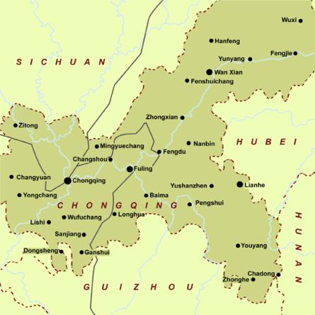
local administrative unit in China (refer to Annex A). It covers an area of 82,040
square kilometres and administers 43 districts, cities and counties, 5 of
which are autonomous counties. Within
the city administration, there are 1,502 town and township offices. The rural population within
Chongqing is about 24.5 million, or 80 per cent of the total. The overall population density is 375
people per square kilometre. Minority
(ethnic) groups represent about 6 per cent of the total population and live
mainly in the southeast portion of the municipality. Chongqing differs substantially
from the other three municipalities that are equal to provinces – Beijing, Shanghai and Tianjin -- and they
also differ from each other, as well as from the three other cities in China
with more than 10 million people. Chongqing is much larger in
area, equivalent to about 290 kilometres by 290 kilometres. In comparison, Beijing has 16,808 square
kilometres (129 x 129), Tianjin has 11,300 square kilometres (106 x 106) and
Shanghai has 6,340.5 square kilometres (80 x 80). Chongqing’s land area is not
square, however, having a maximum span of 470
kilometres from east to west and 450 kilometres from north to south. It occupies almost all of the southeast
portion of what was previously Sichuan Province and
borders Hubei Province
and Hunan Province in
the east, as well a Guizhou
Province in the south.
As can be seen from the map, the
city of Chongqing comprises only a small portion of this area. It is not a “megacity” in the normal
sense. The population of Chongqing
City is about 2.5 million people, but the combined urban population
surrounding the city is about 3 million and is expected to grow substantially
within the current decade. Chongqing
will soon be a megacity and all five elements in the current urban
development strategy of China will be reflected in its growth process. Like the nation as a whole,
Chongqing Municipality must accommodate the majority of its citizens who now
reside in rural areas. The 20 per
cent who live in urban areas undoubtedly provide a comparatively large share
of municipal revenue, and balancing the development needs of the rural
residents with increased services required for those urban dwellers will be a
continuing problem. Much of the development strategy
of Chongqing will focus on the co-development of rural agriculture and urban
industrialisation. Rural-urban
linkages must be firmly established with a solid network of small towns that
are capable of growing into medium-sized cities. Urban centres in regional areas will be needed to effectively
maintain this network within the overall structure of the municipality. Most of the infrastructure
development during the past few years has focused on Chongqing City. This can be attributed to several factors: First, development of Chongqing
City lagged behind that of China’s coastal cities. The World Bank reported that between 1987 and 1992 Chongqing’s
per capita income was between 30 and 40 per cent lower than that of other
major cities. Second, the location of
Chongqing city at the confluence of the Yangtze and the Jialing Rivers makes
it a natural commercial hub for the region now contained in the
municipality. Its early industrial
base was relatively broad, including coal, iron, petroleum refining,
metallurgical, chemical and petrochemical operations. The more recent development of light
industry such as electronics, food processing and cosmetics broadened the
base even further, giving it a substantially greater growth potential than
most of the other urban areas within the municipality. Third, as a result of more rapid
economic growth since 1992, Chongqing City experienced substantial
rural-to-urban migration, with about 20 per cent of population classified as
a “floating population”. Improvements
in urban services, such as water supply and wastewater treatment, were
urgently needed. As a result of these factors,
the capacity of Chongqing City to attract direct foreign investment was
limited. The infrastructure
development was intended partly to enhance the appearance and liveability of
the city and to exploit its natural surroundings with waterways on three side
and mountains on the fourth side. Additional problems arise from
the construction of the Three-Gorges Project, which will lead
to the forced migration and relocation of a large number of inhabitants in
the catchment area of the project.
The area to be submerged by the dam within the next several years will
affect 18 towns and counties with about 715,000 people. By 2009, when the Three-Gorges Project is
expected to be completed, the total population to be relocated will reach
1.07 million people. The planned relocations are
projected as follows: v
In 1997, when the Yangtze River was initially diverted
to allow construction of the dam, 13 county towns, 73 factories and 22,400
inhabitants in the “first line” of the water level at 90 metres were
relocated. v
From 1998 to 2003, 31 county towns, 393 factories
and 527,000 inhabitants in the “second line” of the water level at 135 metres
will be relocated. v
From 2004 to 2006, 15 country towns, 211 factories,
11 hydro power stations and 220,000 inhabitants will be relocated. v
From 2007 to 2009, 51 country towns, 703 factories,
25 hydraulic power stations, 497 docks, 842 km of highways and 280,000
inhabitants will be relocated . These relocations of people are,
in principal, to be matched with the concurrent relocation of towns and
factories, as well as the creation of new towns and factories. The larger urban areas, such as Chongqing
City, Wanxian and Fuling, are expected to provide
temporary accommodation if the relocations lag behind the rising water
levels. Environmental problems are also
substantial. According to a World
Bank evaluation, Chongqing City is the largest
source of organic water pollution in the Yangtze River Basin upstream of the
Three Gorges Dam. So far the Yangtze
River has been able to absorb urban, agricultural, and industrial pollution
loads while maintaining acceptable water quality, due mainly to the river’s
strong flow and high velocity. However, the completion of the
Three Gorges Dam will reduce the velocity of the Yangtze River, increase its
water depth, and alter the flow regime.
“From a river basin perspective, Chongqing needs to be concerned with
maintaining a water quality which will avoid eutrophication of the future
reservoir. From a local perspective,
Chongqing must ensure that its supply of safe water is not endangered by
deteriorating surface water quality, in particular near water intakes” (see
reference for the World Bank document at the end of these notes). In addition, the municipality
must adjust its urban environmental infrastructure to the heightened water
level. For example, two of Wanxian’s
water supply plants will be submerged, parts of the sewer system and
wastewater treatment plants will be flooded, and open dumpsites located near
the river will be washed out. Urban development problems in
Chongqing are therefore more substantial, and more imperative, than those
associated with most other cities in China.
However, they do not differ in substance. All cities in China will face similar problems, but fortunately
on a smaller scale and without the time-span pressure from rising water.
|
|
|
|
|
|
Indirect
linkages are more subtle, and more varied.
They exist within the context of China’s struggle to achieve a stable
compromise between central control and local autonomy. For this, a restatement of past
experiences is useful. China
achieved a relatively stable urban-rural environment from the Tang Dynasty to
the formation of the First Republic in 1911.
We noted, however, that the system was inflexible and could not adjust
to new technology. The
period after 1911 was one of regional chaos and anarchy, sometimes referred
to as the warlord era. Mao Zedong
re-established central influence and control in 1949 by replacing the mandarins
with Party cadres. This also proved
to be inflexible, but for different reasons.
The cadres were unable to alter or to adjust the centrally planned
production targets in response to local market conditions. The
reform process that began in 1979 introduced flexibility, but it is easier to
change the rules than to change behaviour patterns that were established with
the superseded rules. Rule changing
is part of the process that is often referred to as economic and social
liberalisation, or deregulation. Its
basic characteristic is greater freedom of choice and an increase in
individual responsibility in making decisions. Behavioural
problems arise when the liberalisation process has “loop holes”, or gaps,
that can be exploited by a segment of the population. This is generally destabilising since it
encourages widespread evasion of the new rules. Perhaps
more importantly, the liberalisation process loses its flexibility if it is
maintained in a straight line, that is, if is not allowed to adjust to changing
circumstances. Even if behaviour
patterns are set to be coincident with the process at any given time, it is
likely that they will move off on a tangent when the liberalisation process
changes. Therefore,
the sequence and timing of liberalisation become important in avoiding, or in
minimising, the imbalances associated with the lack of coincidence between
rules and behaviour. Failure to
correct the “tangencies” may result in a backward bending of the liberalisation
process. Much
of China’s economic reform during the 1980s and early part of the 1990s has
been described as “two steps forward and one step backward”. It is sometimes viewed as a failure of the
reform, but is more easily seen as part of China’s step-by-step
liberalisation and of the adjustments associated with it. It is nevertheless consistent with a
backward bending process, and urban development in China has not escaped this
problem. The
five elements in the current urban development strategy
are jointly comprehensive. The basic
problem will be in achieving a sequence and timing that allows implementation
of the strategy to be similarly comprehensive. The
current setting for such a sequence and timing is incomplete in the sense
that the various decision-making units are not linked as effectively as they
were in the early period by the mandarins, and in the later period by the
Party cadres who were responsible for the respective work units. It is
likely that the linkages will require the participation of non-government
organisations (NGOs) that are recognised by the respective government
authorities and are fully accepted by the decision-making units. These are already starting to form in
China, but the nature of their network or structure has not yet emerged. The
network must necessarily differ from that of the mandarins, since that cannot
be replicated in the modern era. It
must also differ from that of the Party cadres of the Maoist era, since the
lowest level of that structure was necessarily dispensed with during the
liberalisation process. It may,
however, require some of the elements of each of these. It is
not certain whether urban-based NGOs can successfully link up with
rural-based NGOs while retaining the principal interests of their respective
constituents. There is also a need
for a delicate balance between government recognition (to give the NGO
network authority) and government dominance (which could create mistrust). We
believe that the Chongqing arrangement represents an opportunity for a
desirable network or structure to emerge.
The urgency of relocating inhabitants from the low-lying areas along
the Yangtze, combined with the strong desire to reduce the development
disparities between the coastal provinces and the western region, could serve
to underscore the mutual benefit that NGO linkages could produce. Chongqing
City must be linked to its satellite cities to allow efficient transport and
distribution for trade with other regions in China, and with other
nations. The satellite cities must be
linked with county-level towns surrounding them and the surrounding towns
must be linked to their respective hinterlands in order to benefit the 80 per
cent of the population living in those hinterlands. This
would seem to provide a natural structure for organisational linkages, but
visualising it is likely to be much easier than achieving it. This will most probably be a major
development issue for China during most of the current decade. For
this reason, the Chamber adopted a Key Cities approach with a view to
observing and perhaps participating in these developments. Similarly, the importance placed on NGOs
explains why the home page of this Internet site gives emphasis to the
“establishment of strong and lasting economic linkages between non-government
organisations in Australia and China”. |
|
|
|
|
|
A number of treatises are
available, but two are particularly good since they are concise and are
available online: US Library of Congress, China Country
Study, is
a comprehensive document containing numerous chapters on history, social
development, the economy, politics, literature and many others. The site address gives a table of contents
with links to separate pages for each heading and sub-headings. It is useful mainly for background
information, as it has not been updated for recent developments. The URL for
the country index page is: http://lcweb2.loc.gov/frd/cs/cshome.html Frankenstein, Paul, Brief History
of China is a popular reference to China's history and is now updated
with graphics and links to other sources.
The URL is: http://www-chaos.umd.edu/history/welcome.html Shanghai’s
Development History A useful reference is a student
project described in another portion of this Internet site (see “Student
Essays and Projects” on the home page)”: Huang Nanzhen, “Urban History of
Shanghai”, http://hhhnz.freewebspace.com/Introduction.htm. Wuhan’s Development
History Background information from: China Travel: http://www.chinaetravel.com/city/c057.html China Pages: http://www.chinapages.com/hubei/wuhan/wuhan_s.htm Chongqing’s
Development History Both background and detailed
information from: Chinese Culture: http://chineseculture.about.com China Travel Service: http://www.chinats.com/chongqing/index-01.htm World Bank: http://www.worldbank.org/nipr/china/pids/chongue.htm Current Development
Strategy for China Koop, Marissa, “Urbanisation and
Urban Development in China”, also described in “Student Essays and
Projects”. The text is available at: http://www.accci.com.au/koop.htm. World Bank’s Discussion Papers
(undated) at http://www.worldbank.org: Yang, Weimin, “China’s
Urbanisation Strategy: Priorities and Policies”, Songsu Choi, “Agenda for China’s
Urbanisation Policy: Economic Mobility and Integration”. Ilustrations Zhou Period: The sketch of the area occupied by the
Zhou Dynasty is from Paul Frankenstein (see reference) above. The illustration shown was altered, for
purpose of its presentation here, by means of graphics software. Shanghai: The map of foreign
concessions is from Huang Nanzhen (see reference above). Wuhan map: The area, boundaries and layout are from
Maps of China: http://www.maps-of-china.com
with editing changes for presentation. Chongqing map: Also from http://www.maps-of-china.com with
similar editing changes. |